Welcome to this Learning Management System, Education to All e-learning Platform where you about Levelling Survey under which you would be able to learn different technics in levelling and mapping.
A levelling survey course provides students with the knowledge and skills to measure and determine elevation differences on the earth's surface. It covers the principles of levelling, different types of levelling instruments and methods, and practical applications in various fields like construction and topographical surveys.
Course Overview:
Introduction to Levelling:
This section covers the basic principles of levelling, its purpose, and different types of levelling methods.
Levelling Instruments:
Students learn about the different types of levelling instruments used, such as dumpy levels, automatic levels, and total stations, including their operation and calibration.
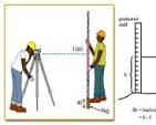
Practical Levelling:
This module focuses on practical application, including setting up levelling instruments, taking readings, and calculating elevation differences using various methods like the height of collimation method.
Data Analysis and Interpretation:
Students learn how to analyze and interpret leveling data, including error analysis, and understand the limitations of different leveling techniques.
Applications of Levelling:
The course explores the application of levelling in various fields, including construction, topographical surveys, and setting out.
Field Exercises:
Practical exercises and fieldwork will be incorporated to enhance students' understanding and practical skills.
Detailed Course Outline of Survey and Levelling Course (2 ...
Detailed Course Outline of Survey and Levelling Course (2 Weeks Course) The document outlines a 6-day surveying and leveling cours...
Survey Equipment Course - GNSS, Drone, Total Station & GPR
The aim of the course is to provide an understanding of surveying and mapping of earth surface using a level, total station, drone
Levelling & Setting Out Surveyor Refresher Course
This course is designed to give junior surveyors, engineers and personnel in the surveying and construction industry a good ground...
Institute of Corporate Learning.
COURSE REQUIREMENT
-Go through everything in this course by doing all the quizes,e-tivities ,pop up questions in the video and always make as done after going through the course.
ASSESSMENTS
CAT 1=50% (Online cat)
CAT 2=50% (E-tivities and Quizes)
END TERM EXAM (Sitting Exams)
*All exams are added up and an average gives you the final score therefore if the average is bellow 35% you will not proceedto the next module.
Levelling in surveying is the process of determining the relative heights of points on the Earth's surface. It involves measuring vertical distances and establishing points at required elevations. This process is crucial for various applications, including construction, land development, and infrastructure project.